Vigilance

Cyclones en cours

NINE22.1N-95.6W

Les traductions sont automatisées

Rechercher

Dépression tropicale NINE en 2026

Le Tuesday 6 October à 21h UTC, NINE est situé(e) sur 22.1 N par -95.6 W (à 231 km à l’Est de Mexico). Son intensité est de 30 kts et sa pression de 1007 hPa. Sur les dernières heures, le système s’est déplacé à 7 km/h à l’ENE. Le vent en augmentation de 5 kts et la pression est en baisse de 1 hPa.

NINE est le 9e cyclone le plus puissant enregistré cette saison avec un vent maximum de 30 kt soit 56 kmh (le plus puissant a été FAY avec un vent maximum de 60 kt soit 111 kmh). Il est le 9e cyclone nommé de la saison 2026 et il est actuellement la 60e dépression tropicale de cette même saison.

Prévisions du NHC :

Tracking NHC pour La Dépression tropicale NINE​

Infos générales du 06/10/2026 à 21h00 UTC

Position

22.1 N / -95.6 W

Catégorie

Catégorie actuelle : Dépression
Catégorie Max : Dépression

Vent

Dernier relevé : 30 kts / 56 kmh
Max : 30 kts / 56 kmh

Pression

Dernier relevé : 1007 hPa
Mini : 1007 hPa

Bulletin NHC


Cartes de prévision pour NINE​

Sources : NHC & NRL

NHC

Image non disponible

NRL

Image non disponible

Modèles de prévision de trajectoire pour La Dépression NINE​

Sources : RAL/NCAR

Trajectoire

Image non disponible

GFS

Image non disponible

Intensité

Image non disponible

Imagerie satellite

Sources : NRL

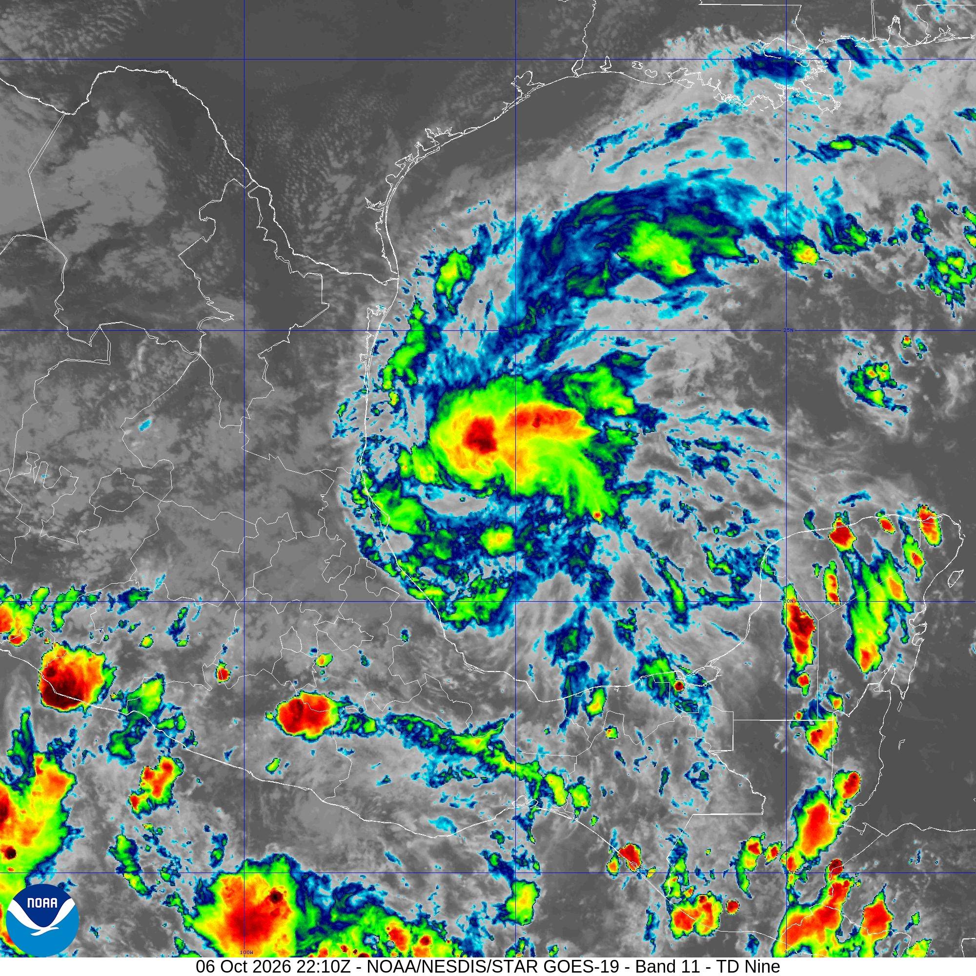
IR

Dépression Nine : image satellite IR sur Meteo Tropicale - cyclones

Visible

Image non disponible

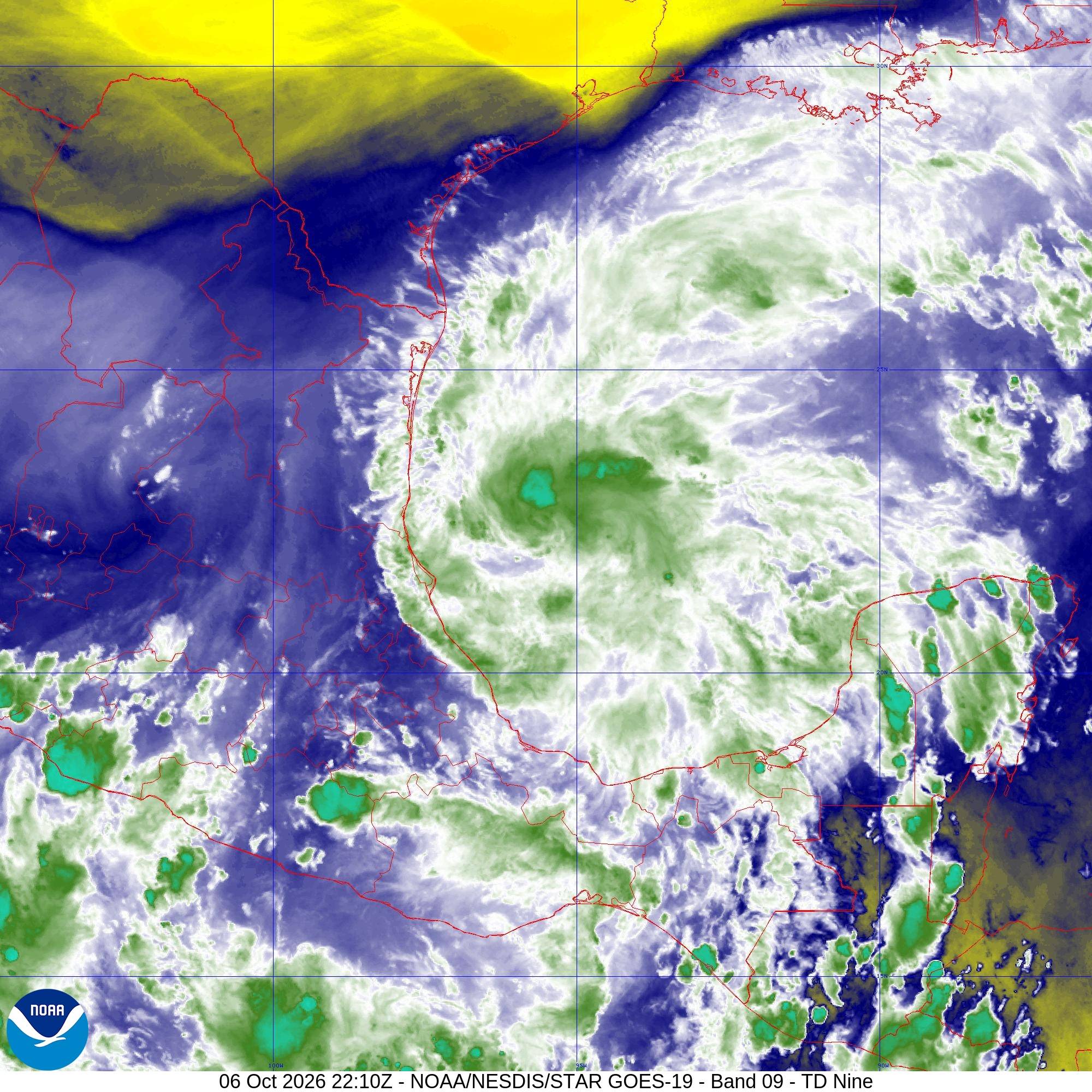
Vapeur

Dépression Nine : image satellite vapeur d

Radar de pluie et foudre autour du cyclone NINE​

Radar précipitations

Impacts de foudre


ZCZC MIATCPAT4 ALL
TTAA00 KNHC DDHHMM

BULLETIN
Tropical Depression Nine Advisory Number 1
NWS National Hurricane Center Miami FL AL092026
400 PM CDT Tue Oct 06 2026

…TROPICAL DEPRESSION FORMS OVER THE GULF OF AMERICA…
…FORECAST TO STRENGTHEN QUICKLY…


SUMMARY OF 400 PM CDT…2100 UTC…INFORMATION
———————————————-
LOCATION…22.1N 95.6W
ABOUT 380 MI…615 KM W OF PROGRESO MEXICO
ABOUT 630 MI…1015 KM SW OF THE MOUTH OF THE MISSISSIPPI RIVER
MAXIMUM SUSTAINED WINDS…35 MPH…55 KM/H
PRESENT MOVEMENT…E OR 90 DEGREES AT 5 MPH…7 KM/H
MINIMUM CENTRAL PRESSURE…1007 MB…29.74 INCHES


WATCHES AND WARNINGS
——————–
There are no coastal watches or warnings in effect.

Interests in the Yucatan Peninsula and the U.S. northern Gulf Coast
should closely monitor the progress of this system.


DISCUSSION AND OUTLOOK
———————-
At 400 PM CDT (2100 UTC), the center of Tropical Depression Nine was
located near latitude 22.1 North, longitude 95.6 West. The
depression is moving toward the east near 5 mph (7 km/h) and an
east to east-northeast motion is expected during the next couple of
days. By Friday, a turn to the northeast is anticipated. On the
forecast track, the depression is expected to pass to the north of
the Yucatan Peninsula on Thursday, and approach the U.S. northern
Gulf Coast on Friday.

Maximum sustained winds are near 35 mph (55 km/h) with higher gusts.
Steady strengthening is forecast, and the depression is expected to
become a tropical storm by early Wednesday and a hurricane on
Thursday.

The estimated minimum central pressure is 1007 mb (29.74 inches).


HAZARDS AFFECTING LAND
———————-
Key messages for Tropical Depression Nine can be found in the
Tropical Cyclone Discussion under AWIPS header MIATCDAT4 and WMO
header WTNT44 KNHC.

RAINFALL: Tropical Depression Nine is expected to produce rainfall
amounts of 2 to 4 inches through Thursday across coastal portions of
the Bay of Campeche with isolated higher amounts possible in the
states of Campeche and western Yucatan.

From Friday through the weekend, the system is expected to produce
rainfall amounts of 3 to 6 inches, with localized totals up to 10
inches, across the central U.S. Gulf Coast extending from
southeastern Louisiana to the Florida Panhandle. Flash and urban
flooding, along with isolated river flooding, will be possible.

For a complete depiction of forecast rainfall associated with
Tropical Depression Nine, please see the National Weather Service
Storm Total Rainfall Graphic available at
hurricanes.gov/graphics_at4.shtml?rainqpf and the Flash Flood Risk
graphic at hurricanes.gov/graphics_at4.shtml?ero.

WIND: Gusty winds are possible in portions of the Yucatan Peninsula
on Thursday.

SURF: Swells generated by the depression are expected to affect the
western and northern portions of the Yucatan Peninsula beginning on
Thursday. These swells are likely to cause life-threatening surf and
rip current conditions. Please consult products from your local
weather office.

A depiction of rip current risk for the United States can be found
at:
hurricanes.gov/graphics_at4.shtml?ripCurrents


NEXT ADVISORY
————-
Next complete advisory at 1000 PM CDT.

$$
Forecaster Cangialosi

NNNN

ATTE

Disclaimer

NTION

Ce site a été élaboré à des fins de divertissement et de compréhension de la météo en zone tropicale.

Il ne doit être utilisé EN AUCUN CAS dans un objectif de sécurité des personnes ou des biens.

Seules les informations de votre service national de météorologie et de votre sécurité civile doivent être utilisées en cas risque avéré !

Compte

Login

[user_registration_my_account]
Météo Tropicale Antilles - Cyclones et ouragans
Résumé de la politique de confidentialité

Nous utilisons des "cookies" pour vous proposer une meilleure expérience de navigation sur notre site et pour suivre les statistiques de fréquentation afin de vous proposer du contenu pertinent.

Vous pouvez à tout moment modifier les paramètres de gestion des cookies vous concernant en cliquant sur les onglets à gauche.