Vigilance

Cyclones en cours


Les traductions sont automatisées

Rechercher

Ouragan Cat. 5 ERIN en 2025 - Dissipé(e) le 23/08/2025

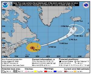
Le Saturday 23 August à 00h UTC, ERIN est situé(e) sur 40.7 N par -57.8 W (à 1123 km au NE de Bermuda). Son intensité est de 80 kts et sa pression de 957 hPa. Sur les dernières heures, le système s’est déplacé à 30 km/h à l’ENE. Le vent et la pression sont stables .

ERIN est le 3e cyclone le plus puissant enregistré cette saison avec un vent maximum de 140 kt soit 259 kmh (le plus puissant a été ERIN avec un vent maximum de 140 kt soit 259 kmh). Il est le 5e cyclone nommé de la saison 2025 et il est actuellement le 3e ouragan de catégorie 5 de cette même saison. ERIN est désormais le 24e cyclone le plus intense dans l’histoire depuis 1950.

Prévisions du NHC :

Tracking NHC pour le cyclone ERIN​

Dernier relevé du NHC avant dissipation pour le cyclone ERIN

Position

Dissipé

Catégorie

Catégorie actuelle : Dissipé
Catégorie Max : Ouragan Cat. 5

Vent

Dernier relevé : 80 kts / 148 kmh
Max : 140 kts / 259 kmh

Pression

Dernier relevé : 957 hPa
Mini : 915 hPa

Bulletin NHC


Cartes de prévision pour ERIN​

Sources : NHC & NRL

NHC

Rémanence Erin : prévision du NHC sur Meteo Tropicale - Meteo des cyclones

NRL

Image non disponible


ZCZC MIATCPAT5 ALL
TTAA00 KNHC DDHHMM

BULLETIN
Post-Tropical Cyclone Erin Advisory Number 46
NWS National Hurricane Center Miami FL AL052025
500 PM AST Fri Aug 22 2025

…ERIN BECOMES POST-TROPICAL, THIS IS THE LAST ADVISORY…
…SWIMMING AT MANY U.S. EAST COAST BEACHES IS LIKELY TO REMAIN
DANGEROUS THROUGH THE WEEKEND…


SUMMARY OF 500 PM AST…2100 UTC…INFORMATION
———————————————-
LOCATION…40.0N 59.7W
ABOUT 605 MI…970 KM NNE OF BERMUDA
ABOUT 375 MI…605 KM SSE OF HALIFAX NOVA SCOTIA
MAXIMUM SUSTAINED WINDS…90 MPH…150 KM/H
PRESENT MOVEMENT…ENE OR 65 DEGREES AT 33 MPH…54 KM/H
MINIMUM CENTRAL PRESSURE…957 MB…28.26 INCHES


WATCHES AND WARNINGS
——————–
There are no coastal watches or warnings in effect.


DISCUSSION AND OUTLOOK
———————-
At 500 PM AST (2100 UTC), the center of Post-Tropical Cyclone Erin
was located near latitude 40.0 North, longitude 59.7 West. The
post-tropical cyclone is moving toward the east-northeast near 33
mph (54 km/h). This general motion with an increase in forward
speed is expected later today, followed by a turn back to the
northeast on Sunday. On the forecast track, the center of Erin
will pass south of Atlantic Canada today and tonight, and then race
across the north Atlantic waters.

Maximum sustained winds remain near 90 mph (150 km/h) with higher
gusts. Erin is likely to remain a large and powerful
hurricane-force low pressure system through the weekend.

Hurricane-force winds extend outward up to 125 miles (205 km) from
the center and tropical-storm-force winds extend outward up to 435
miles (705 km).

The estimated minimum central pressure is 957 mb (28.26 inches).


HAZARDS AFFECTING LAND
———————-
Key messages for Erin can be found in the Tropical Cyclone
Discussion under AWIPS header MIATCDAT5 and WMO header WTNT45 KNHC.

WIND: Gale-force wind gusts are possible along portions of the
coast of Nova Scotia today and the Avalon Peninsula of Newfoundland
on Saturday.

SURF: Swells generated by Erin will affect the Bahamas, Bermuda,
the east coast of the United States, and Atlantic Canada during the
next few days. These rough ocean conditions are expected to
cause life-threatening surf and rip currents. Please consult
products from your local weather forecast office for more
information.

A depiction of rip current risk for the United States can be found
at: hurricanes.gov/graphics_at5.shtml?ripCurrents

STORM SURGE: Some coastal flooding is expected at times of high
tide along portions of the U.S. Mid-Atlantic and New England coasts
through tonight, making some roads impassable. See updates from
your local National Weather Service office for details.


NEXT ADVISORY
————-
This is the last public advisory issued by the National Hurricane
Center on this system. Additional information on this system can be
found in High Seas Forecasts issued by the National Weather
Service, under AWIPS header NFDHSFAT1, WMO header FZNT01 KWBC, and
online at ocean.weather.gov/shtml/NFDHSFAT1.php

$$
Forecaster Blake

NNNN

ATTE

Disclaimer

NTION

Ce site a été élaboré à des fins de divertissement et de compréhension de la météo en zone tropicale.

Il ne doit être utilisé EN AUCUN CAS dans un objectif de sécurité des personnes ou des biens.

Seules les informations de votre service national de météorologie et de votre sécurité civile doivent être utilisées en cas risque avéré !

Compte

Login

[user_registration_my_account]
Météo Tropicale Antilles - Cyclones et ouragans
Résumé de la politique de confidentialité

Nous utilisons des "cookies" pour vous proposer une meilleure expérience de navigation sur notre site et pour suivre les statistiques de fréquentation afin de vous proposer du contenu pertinent.

Vous pouvez à tout moment modifier les paramètres de gestion des cookies vous concernant en cliquant sur les onglets à gauche.