Current cyclones and Watching


Storm Gonzalo - # 5 - July 23 21h UTC

Le 23 juillet 2020 à 17:20

By Olivier Tisserant
4.9/5 (31)

Reminder: the information and illustrations on this site are NOT INTENDED to protect property and people from cyclonic risks. For this, you must follow the information and recommendations of your prefecture for France and the competent authorities for other territories.

An update for this article is available HERE.

Gonzalo continues to struggle with the dry air and sand in his surroundings. Until now there were pauses in its strengthening when its organization was weakening but today it is its intensity that has decreased in the afternoon to drop to 50 kts instead of 55 this morning. This is the first time in 3 days that he has weakened.

Le nhc remains very doubtful about its future but begins to reduce its intensity for the passage over the arc with a forecast in storm and more in hurricane. Numerical models continue to be very divided in their vision of the intensity for the next few days, but overall the forecast is weaker than in recent hours, which is rather a good sign!

Storm Gonzalo - NHC - forecast for July 23, 2020 at 22 p.m. UTC

Situation

Storm Gonzalo remains very compact and quite disorganized. Its position at 21h UTC was 9.8N by 49.4W with a movement still to the west (270 °) a little faster. The pressure rose to 1000 hPa and the intensity is 50 kts with much stronger gusts.


Intensity

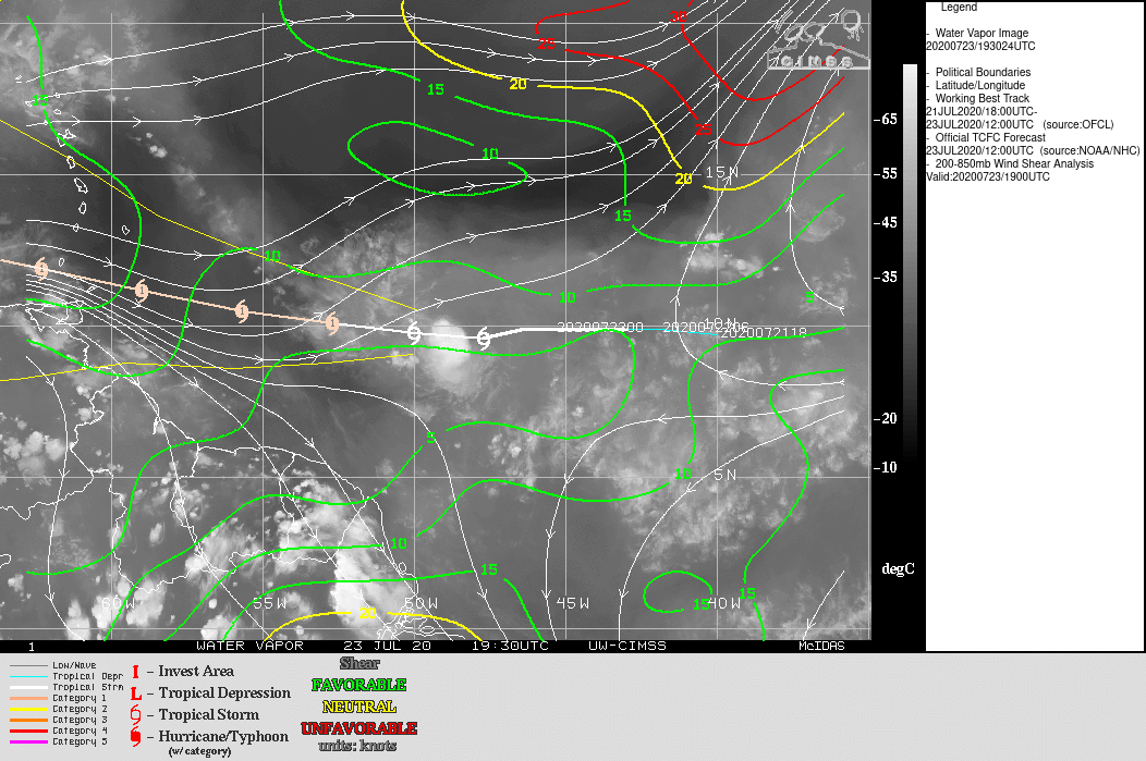
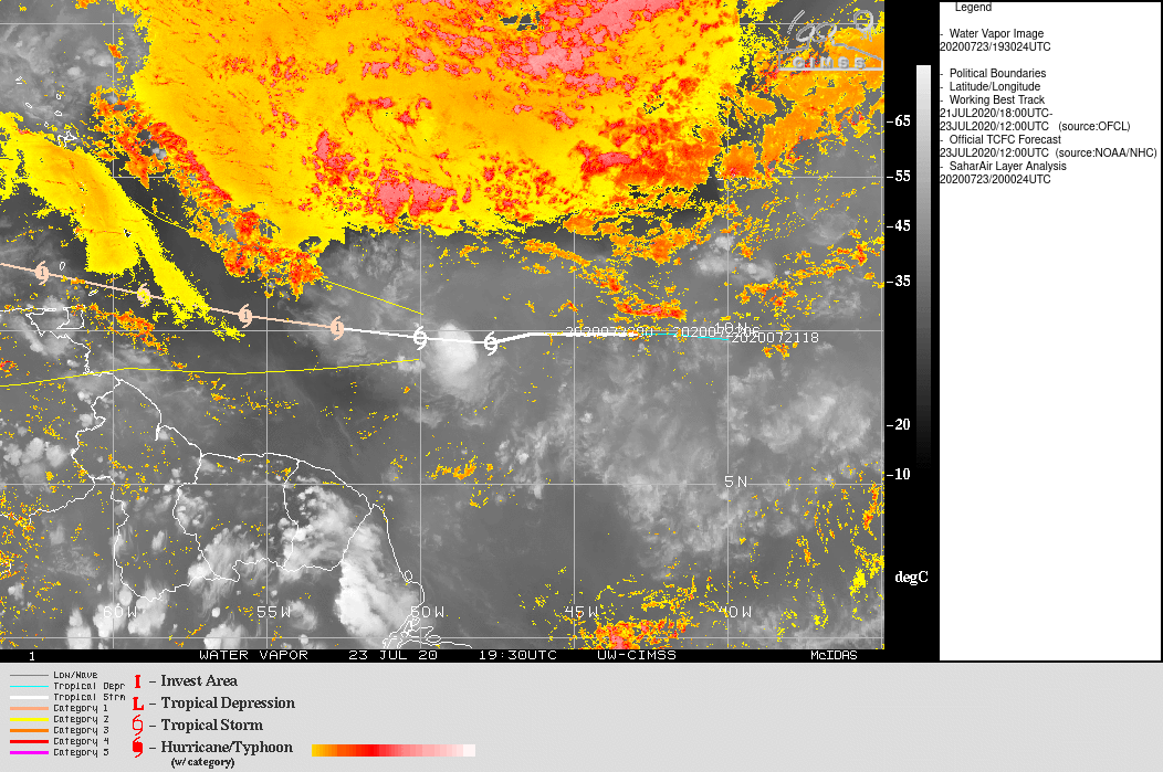
Gonzalo continues to experience the ingress of dry air and sand in his circulation and he begins to have difficulty recreating convection after his phases of disorganization. For the first time since its classification in cyclone its intensity weakened and did not resume then. The nhc gradually began to lower its intensity forecast and no longer considered it to be classified as a hurricane when passing over the arc. It nevertheless maintains the risk of passenger reinforcement before crossing. It is a position which may seem conservative but which arises from the mistrust of a cyclone which has been largely unpredictable from the start.

Storm Gonzalo - intensity forecast on June 23, 2020 at 18 p.m. UTC
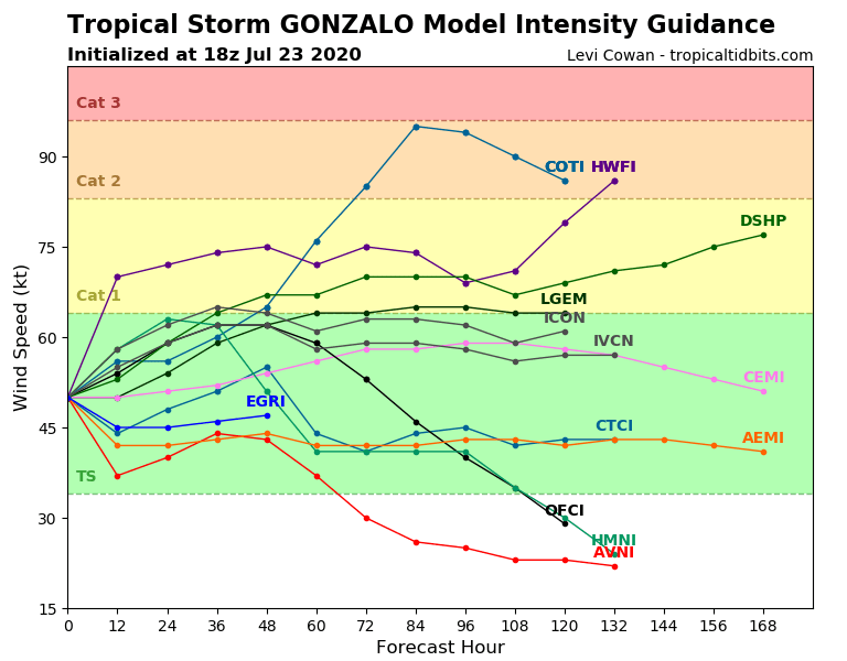
The numerical models remain very divided on the forecast of intensity but they have almost all taken into account a drop (sometimes significant) compared to the last runs. We have no consensus on its intensity to come but we have one on the fact that it is potentially less strong than envisaged these last 36 hours.

All intensity forecasts are down and this is excellent news, although we must remain cautious.

Path

Storm Gonzalo - track forecast for July 23, 18h UTC
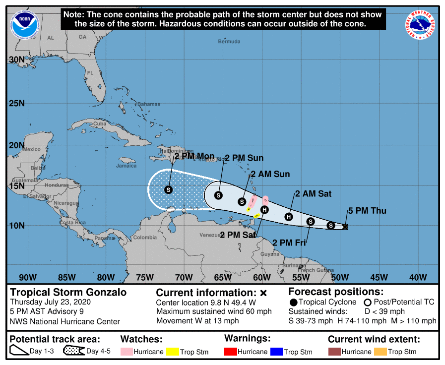
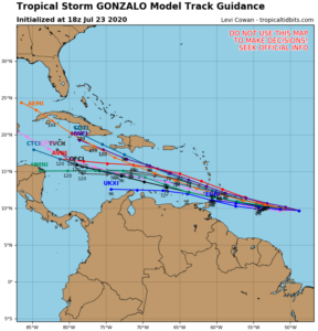
The trajectory forecast remains consensual for a passage over the south of the arc even if there is a slight inflection towards the north, as well for the nhc only for the consensus of models. The high pressure ridge seems to be moving a little further north than expected for the models, which leaves a little more room to climb slightly. However, this adjustment remains very low and well below the trajectory uncertainty which remains greater than 100 km at this time and is therefore not of great importance.

The displacement is still due west for the moment, but the speed has increased a little to 21 km / h.

Environmental

Gonzalo's environment is always very contrasted and this is what explains these recurring problems in predicting his intensity (in addition to his very compact size). The water is around 29 ° and close to 30 on its trajectory, the shear remains very weak (but that could change a little after the West Indies) but the dry air and the sand are still very present in its immediate north and its small size prevents it from rebuilding the deep convection a little extended nearby from its center.

Conclusion

We can't yet shout “Victory” but things are moving in the right direction and Gonzalo seems to give in little by little under the onslaught of the dry air.

But the other conditions being extremely conducive to strengthening, it is necessary to be careful not to relax. Quite a few models and the nhc continue to predict a hurricane passage over the next few hours and a hurricane on the West Indies route, this is not at all trivial and we must take it very seriously.

(Concerning the wave leaving Africa that theECMWF extension and l'ICON announce in significant reinforcement on the West Indies at 7 days, I will speak about it tomorrow or this WE).


To follow the evolution in real time of this weather system, it's here: Tropical Storm Gonzalo

Please rate this item

Comments

Subscribe
Notification for
guest
1 Comments
The oldest
Most recent The most popular
Online comments
Show all comments
trackback

[…] More HERE on Météo […]

Translations are automated.

Current cyclones and Watching


Latest videos

ATTE

Disclaimer

TION

This site has been developed for entertainment and understanding the weather in the tropics.

It should only be used NEVER for the safety of people or property.

Only information from your national meteorological service and your civil security should be used in case of proven risk!

Account

Login

[user_registration_my_account]