
It is not a question here of comparing the violence suffered by the territories affected by hurricanes. Each system is unique and specifically impacts a location. There is no need to compare or rank these woes. On the other hand, it is interesting to see if the trend of these rapid reinforcements is on the rise and to see how Hurricane Laura fits into this trend.
This hurricane is catastrophic. It has sown and is still sowing, as I write these lines, chaos in southern Louisiana. It is a category 4 hurricane (almost category 5 on the last wind records) destructive and of incredible violence. It is of course not a question of calling these facts into question. But its strengthening in the Gulf was very rapid, so much so that it raised quite a few questions on social networks: is it the fastest strengthening observed? is it faster than Maria's in 2017? … Etc.
I will try to answer these questions.
How do you determine the rate of strengthening of a cyclone?
It's pretty straightforward. According to the readings (or estimates) carried out every 6 hours by the nhc, we will determine the biggest increase in wind per 24 hours. It is a sliding calculation, that is to say that it compares the last 24 hours every 6 hours and not just from midnight to midnight.
The use of wind speed rather than pressure has two explanations: the first is that the intensity of a cyclone (ranking on theSaffir-Simpson scale) is carried out according to the wind speed and not to the pressure. The second is that the history of cyclones systematically has wind speed values while pressure values are sometimes absent before the end of the 60s. To make statistics, there is therefore no other choice than to use the wind speed, even if the pressure might seem more suitable because of its less volatility from one reading to another.
What is the maximum strength of Hurricane Laura?
Laura was classified as a tropical storm a little before the West Indies. This classification was maintained until arriving in the Gulf of Mexico, leaving the coast of Cuba. From that moment the cyclone began to strengthen to reach Category 4:
- Entry into the Gulf of Mexico on 25/08 at 6 a.m. UTC at 60 kts
- Passage to category 1 on 25/08 at 12 p.m. UTC at 65 kts (+ 6h)
- Passage to category 2 on 26/08 at 6 p.m. UTC at 90 kts (+ 18h)
- Passed into a major hurricane of category 3 on 26/08 at 12 p.m. UTC at 100 kts (+ 6h)
- Passed into a major hurricane of category 4 on 26/08 at 18 p.m. UTC at 120 kts (+ 6h)
- Maximum wind recorded on 27/08 at 0h UTC with 130 kts (+ 6h) ... it's just 6 kts below the classification in category 5.
These readings are those standardized for nhc. There may be deviations of a few hours with the live situation which is updated every 3 hours. But for statistical and comparison purposes, only the data from 0h, 6h, 12h and 18h are used. It smoothes the reinforcement peaks a bit and over a comparison period of 24 hours it has no impact. If the comparison was made every 6 hours, it could distort the ranking a little.
We can start by seeing that Laura went from tropical storm to category 4 hurricane in 36 hours with a wind strengthening of 60 kts in 36h. The fastest reinforcement took place on August 26 between 6 a.m. and 18 p.m. with a change from category 2 to category 4 and 90 kts to 120 kts in 12h. The biggest evolution over 24 hours is between August 25 at 18 p.m. and August 26 at 18 p.m. with a strengthening of the wind of 50 kts.
This is very important, but what about the others?
What about the strengthening of Hurricane Maria in 2017
Hurricane Maria impressed everyone with its building capacity. During his evolution he went directly from category 3 to category 5 in 6 hours between September 19 at 18 p.m. and September 20 at midnight off Martinique. From 0 to 110 kts, or 35 kts in 6 hours, compared with the 30 kts in 12 hours from Laura.
Over 24 hours the maximum reinforcement recorded for Maria was 70 kts between September 18 at midnight and September 0 at midnight.
70 kts in 24 hours for Maria and 50 kts in 24 hours for Laura.
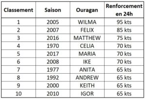
The 10 most important reinforcements since 1950
I based the comparison between 1950 and 2019 because before the reliability of the data is much less relevant before. We can already estimate that before 1966 and the satellite images reliability was less good, but we have to start somewhere.
This ranking is a bit of a horror as it shows the 10 hurricanes that have strengthened the fastest over the Atlantic.
There are several important elements:
- The 3 fastest reinforcements have taken place in the last 15 years. And 7 of the 10 fastest have been in the last 20 years. There is clearly an evolution in the rate of strengthening of these large cyclonic systems.
- 7 of these hurricanes were classified in category 5. 2 in category 4 at most and 1 (Celia) in category 3 at most. But these are all major hurricanes.
- The 3 fastest reinforcements took place in the Caribbean Sea. Of the 10, 4 took place in the Caribbean, 3 in the Gulf of Mexico and 3 in the Atlantic.
- Igor is the system that has strengthened the most quickly the further west since it went to Category 4 before 50W.
- 9 of these 10 very fast reinforcement systems impacted the soil, but not always at their maximum power. Only Maria touched an inhabited land at its max power.
- Maria and Igor are a bit of the exception. They strengthened in the Atlantic, before 60W and south of 20N. It is this kind of reinforcement that the West Indies must fear the most. Irma has strengthened more slowly but remains in this kind of systems.
- In this ranking, Laura would be around the 30th place….
Conclusion
Laura strengthened very quickly in the Gulf of Mexico. But its strengthening is very far from the records in the field. Wilma got stronger 95 kts in 24 hours. It's just amazing. The passage from the storm stage to category 5 in 24 hours.
These explosive reinforcements are more and more frequent. It will be necessary that researchers look at this question (a study of last year published in Nature already addresses this subject but in a way too superficial). They pose an increasingly important danger to the territories, in particular those to the west of 65W, that is to say after the West Indies.
Another problem is the difficulty of models to predict this sort of thing. The GFS for example totally missed his 5-day forecast for Laura by anticipating a tropical wave instead of a category 4. TheECMWF extension and HWRF on the other hand, were very consistent on this forecast over the previous 120 hours.
Finally, it should be noted that the nhc performed very well on this forecast. They identified the reinforcement and the impact zone very precisely at more than 4 days. Only the planning was a little tricky. It's a huge performance, especially given the difficulties in positioning Laura correctly before she crosses into the Gulf of Mexico. The NOAA has sent no less than 25 planes (yes 25!) into this system since its classification as a pre-arc storm, half of which from its arrival in the Gulf of Mexico. These flights made it possible to collect an incredible volume of data which allowed the models to be fed and forecasters to clearly identify this cyclone.
The question will have to be asked one day: why Météo France has no air resources at all? It is not a question of having ten devices like the NOAA but already 1 which could go into investigation around 50W… where a lot of things are being decided for the systems which threaten the West Indies. The Watching and alert procedure would be greatly improved and at the same time the consequences could be reduced. For the moment, we are content with information from the Americans…. but what if tomorrow they decide that it costs too much for them to go and do this kind of thing so far from home? (Yes, I know, as WMO focal points for the region and cyclones, they get help and that's a big part of why they do all this work, even away from home. having a little independence on the subject would not be a luxury).
Image credits; Tropical tidbits, NHC / Noaa, UW-CIMSS

