
Reminder: the information and illustrations on this site are NOT INTENDED to protect property and people from cyclonic risks. For this, you must follow the information and recommendations of your prefecture for France and the competent authorities for other territories.
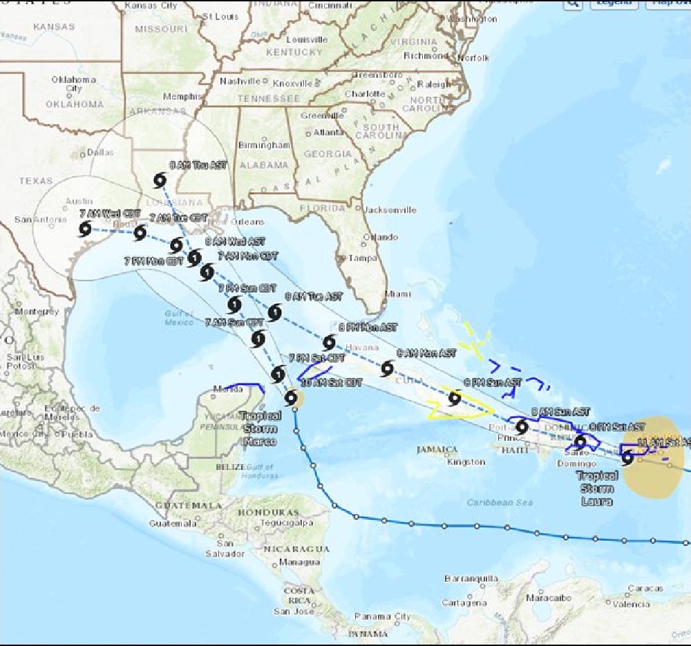
The situation facing the United States, at least the states bordering the Gulf of Mexico, is rare, and even more so in the context of a direct threat to inhabited land. 2 cyclones, potentially 2 hurricanes, could occur at about the same time, in the same area, not very far from land.
The Fujirawa effect
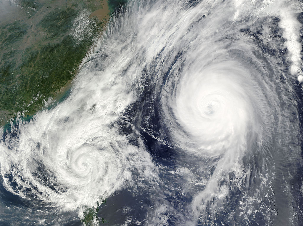
The interaction of 2 cyclonic type weather systems is known and documented. This is called the Fujiwhara effect (or often Fujiwara in French).
The cases recorded in history have mainly been observed in the open sea. Cyclones with different trajectories meet, most often in the Pacific and… what happens?
The organization of a cyclonic system is a very complex alchemy and many parameters intervene and coexist so that the system stabilizes in its instability. And the thing most likely to weaken it is a significant change in its surrounding parameters. And what could be worse in the environment of a cyclone than another very close cyclone?
What is the risk of a Fujiwhara effect?
There are 2 distinct cases in this kind of situation:
- One of the 2 cyclones is more powerful and important than the other
- The 2 cyclones have more similar characteristics
In the first case, the result is most often the same: the “small” cyclone is found entrained in the vortex of the second and is sprayed as it approaches the center by turning around it. It's the most frequent case. But the bigger of the 2, even if he survives, will be modified by this encounter. Its circulation will have been impacted and most often it will become disorganized, at least temporarily. And its trajectory has a good chance of being impacted too, sometimes quite markedly.
In the second case, the outcome is more uncertain. They will at first turn around each other in a sort of dance, admittedly visually magnificent, but not very pleasant for the inhabitants nearby. Then, 3 types of exits can appear in a more or less long time: most often they will end up pushing each other and going on their own, sometimes one of the 2 will weaken and it ends as in the previous case and, the rarest, they merge to form a stronger system.
Why is the merger into a large system unlikely for Hurricanes Laura and Marco in the Gulf of Mexico? already because the place is limited and the interaction with the earth will weaken one of the 2 or the 2. Then because hostile conditions are expected (shear important) on the area at this time. Finally, because in principle these will not be extremely powerful systems (storm or Cat1 planned for the moment).
So why bring up the subject if the risk is so low?
Quite simply because the risk is elsewhere.
The most important is the arrival at the same place of 2 hurricanes 24 hours apart. Those of you who have been through one of these systems understand what I am talking about. The significant damage caused by the wind or the rain created by the former makes the populations and infrastructures very fragile. The passage of a second, shortly after, immobilizes the aid and the impact is more violent because the infrastructure (housing in particular) is weakened. It is potentially a real nightmare that can be worse in terms of loss of life than a single more powerful system. And the risk that the second is more powerful than expected is real because the first will humidify the atmosphere and modify the altitude currents and therefore the shear.
The other risk is that the famous “dance” of the 2 systems lasts too long. Taking into account the small size of the Gulf of Mexico, the entry into rotation of 2 systems would imply catastrophic rainfallss on the coasts while all that calms down. 24 hours of torrential rains in areas already swampy by nature such as southern Louisiana could be dramatic.
What will happen between Cyclones Marco and Laura in the Gulf of Mexico?
It is already difficult to predict the future of a 3-day cyclone, so that of 2 cyclones in 4 or 5 days is more like clairvoyance. Cyclone Laura is likely to spend a lot of time over land and lose a good deal of its intensity, especially given its speed of movement. So nothing today indicates that the risk that they meet is greater than that of avoiding each other. And even their respective trajectory is still very uncertain.
But there is nevertheless a risk that something very delicate will take place there within a few days. And hardly any forecasting model is able to predict what would happen in this case. And if that happens we will have to hope that it is not as dramatic as it can be.
The “dashboard” tool allows direct monitoring of the situation on all the coasts affected by cyclones, on the Atlantic, the Caribbean Sea and the Gulf of Mexico… and that's HERE.
Image credits; Tropical tidbits, NHC / Noaa, UW-CIMSS

