Current cyclones and Watching


Tropical Depression 7 - # 2 - July 22 10:30 UTC

Le 22 juillet 2020 à 6:15

By Olivier Tisserant
4.97/5 (36)

Reminder: the information and illustrations on this site are NOT INTENDED to protect property and people from cyclonic risks. For this, you must follow the information and recommendations of your prefecture for France and the competent authorities for other territories.

As was widely anticipated, theInvest 99L was classified as a tropical depression (TD7) last night. As conditions remain partially favorable, a tropical storm classification is envisaged for the day, giving birth to a Gonzalo whose name has left a bitter memory in the north of the Caribbean arc in the past.

It is at the moment a very compact cyclone which moves slowly, which is quite unusual. It should nevertheless accelerate as of today. Its current organization on satellite images is that of a storm with conspicuous convective concentric bands and a compact but well present deep convection.

Tropical Depression 7 - satellite image - July 21, 2020

Situation

The low is this morning on 10N / 42W and is moving towards the WNW at just under 20 km / h. The pressure in the center is of the order of 1007 hPa with sustained winds of 30 kts (with stronger gusts), or very close to 35 kts necessary for storm classification.

Intensity

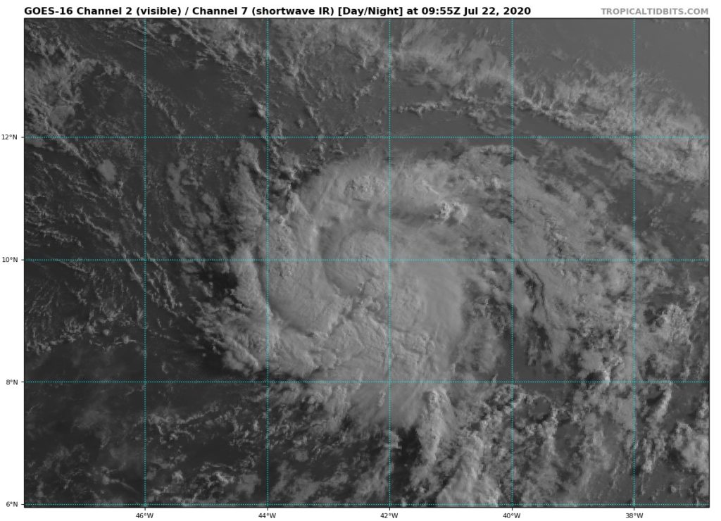
This system, well organized despite the presence of dry air and sand to its north, is very compact. He manages to maintain good convection in the south. Its current intensity is 30 kts but should intensify in the next few hours. For the rest, there remains a lot of uncertainties due to the presence of this pocket of dust and dry air in the north which moves faster than it.

Tropical Depression 7 - intensity forecast July 22


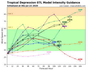
The models disagree quite strongly (it is quite unusual at this level) on the intensity forecast and no consensus emerges from the 06H runs. Their individual bias regarding the impact of dust and dry air is widely felt. Under these conditions, we mainly look at the generally efficient global models, namely the GFS and l'ECMWF extension. The 2 are quite in agreement for a strengthening in the next few hours then a stabilization or a weakening from Thursday / Friday which corresponds to the forecast of the nhc which does not envisage classification as a hurricane.

Path

The current track is very close to the west and should stay that way for the next few hours.

Tropical depression 7 - track forecast for July 22, 2020

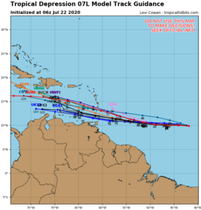
Unlike that for intensity, the trajectory forecast is rather consensual. This is also a little surprising given that the intensity often has a marked effect on the trajectory of cyclonic systems! There is therefore a consensus for a passage over the southern half of the West Indies. It is also the position of the GFS and ECMWF extension. THE nhc is on a trajectory forecast based on this consensus.

However, I would like to draw attention to the uncertainty of these forecasts and the need for the bordering islands to remain vigilant (I am thinking especially of Martinique). Keep in mind that the wind is stronger north of a dominant westward moving system. The good news is that its compactness should largely limit the wind area around its center.

Environmental

The environment remains rather favorable to reinforcement with water around 28 ° and almost no shear. There is however quite a bit of dust and dry air to the north and this is probably what maintains a compact size by blocking convection over the northern part of the depression.

For the next few days, the conditions could become a little more unfavorable since by going up a little north it will get closer to the area of ​​dust and dry air. At the same time, medium and high altitude wind currents could experience a not insignificant differential, which would have the effect of creating shear.

Conclusion

These coming hours will be important for the future of this system. Its resistance to dry air and its real trajectory will determine the level of impact and its zone at the level of the West Indies.

Boats currently south of the arc (between Saint Lucia and Trinidad) must begin to prepare for the passage of this system and experience a tropical storm. Those in Martinique must remain vigilant because a trajectory a little more north (with a slightly stronger intensity) is not excluded by some models.

I will make another point after the 18H models were released.

To follow the evolution in real time of this weather system, it's here: Tropical Depression 7

Please rate this item

Comments

Subscribe
Notification for
guest
0 Comments
Online comments
Show all comments

Translations are automated.

Current cyclones and Watching


Latest videos

ATTE

Disclaimer

TION

This site has been developed for entertainment and understanding the weather in the tropics.

It should only be used NEVER for the safety of people or property.

Only information from your national meteorological service and your civil security should be used in case of proven risk!

Account

Login

[user_registration_my_account]