Current cyclones and Watching


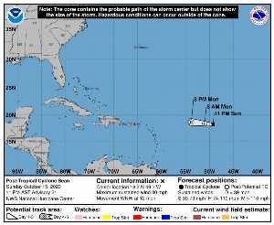
On Monday October 16 at 03:XNUMX UTC, when it dissipated, SEAN was located at 18.2 N at -49.3 W (1242 km ENE of Barbados). Its intensity was 25 kts and its pressure of 1011 hPa. This cyclone did not impact any territory.

SEAN (Eg Invest 92L) is the 18th strongest cyclone recorded this season with a maximum wind of 40 kt or 74 kmh (the most powerful was LEE with a maximum wind of 145 kt i.e. 269 km/h). It was the 19th named cyclone of the 2024 season and is currently the 19rd tropical storm of this same season.

SEAN lasted 9 days.

NHC tracking for cyclone SEAN​

Last statement of nhc before dissipation for cyclone SEAN

Position

Dissipated

Category

Current Category: Dissipated
Max Category: Storm

Wind

Last reading: 25 kts / 46 km / h
Max: 40 kts / 74 km / h

Pressure

Last reading: 1011 hPa
Mini: 1004 hPa

NHC Bulletin


Forecast maps for

sources: nhc & NRL

nhc

Post-tropical cyclone Sean: NHC forecast on Meteo Tropicale - Cyclone weather

NRL

Image not available

Translations are automated.

Current cyclones and Watching


Latest videos


ZCZC MIATCPAT4 ALL
TTAA00 KNHC DDHHMM

NEWSLETTER
Post-Tropical Cyclone Sean Advisory Number 21
NWS National Hurricane Center Miami FL AL192023
1100 PM AST Sun Oct 15 2023

…SEAN DEGENERATES INTO A REMNANT LOW…
… THIS IS THE FINAL ADVISORY…


SUMMARY OF 1100 PM AST… 0300 UTC… INFORMATION
----------------
RENTAL… 18.2N 49.3W
ABOUT 905 MI… 1455 KM E OF THE NORTHERN LEEWARD ISLANDS
MAXIMUM SUSTAINED WINDS… 30 MPH… 45 KM / H
PRESENT MOVEMENT… WNW OR 285 DEGREES AT 12 MPH… 19 KM / H
MINIMUM CENTRAL PRESSURE… 1011 MB… 29.86 INCHES


WATCHES AND WARNINGS
-------
There are no coastal watches or warnings in effect.


DISCUSSION AND OUTLOOK
--------
At 1100 PM AST (0300 UTC), the center of Post-Tropical Cyclone Sean
was located near latitude 18.2 North, longitude 49.3 West. Tea
post-tropical cyclone is moving toward the west-northwest near 12
mph (19 km/h). A turn toward the west with an increase in forward
speed is expected overnight and Monday morning.

Maximum sustained winds are near 30 mph (45 km / h) with higher gusts.
Weakening is forecast, and Sean is expected to dissipate into an
open trough by Monday night or Tuesday.

The estimated minimum central pressure is 1011 mb (29.86 inches).


HAZARDS AFFECTING LAND
--------
none


NEXT ADVISORY
-----
This is the last public advisory issued by the National Hurricane
Center on this system. Additional information on this system can be
found in High Seas Forecasts issued by the National Weather Service,
under AWIPS header NFDHSFAT1, WMO header FZNT01 KWBC, and online at
ocean.weather.gov/shtml/NFDHSFAT1.php

$$
Forester Berg

NNNN

ATTE

Disclaimer

TION

This site has been developed for entertainment and understanding the weather in the tropics.

It should only be used NEVER for the safety of people or property.

Only information from your national meteorological service and your civil security should be used in case of proven risk!

Account

Login

[user_registration_my_account]