Current cyclones and Watching


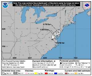
Sunday, September 24 at 09:XNUMX UTC, when it dissipates, OPHELIA was located on 37.7 N by -77.3 W (328 km north of US -> North Carolina). Its intensity was 20 kts and its pressure of 1007 hPa. This cyclone did not impact any territory.

OPHELIA (Eg Invest 99L) is the 8th strongest cyclone recorded this season with a maximum wind of 60 kt or 111 kmh (the most powerful was LEE with a maximum wind of 145 kt i.e. 269 km/h). It was the 16th named cyclone of the 2024 season and is currently the 19rd tropical storm of this same season.

OPHELIA lasted 3 days.

NHC tracking for cyclone OPHELIA​

Last statement of nhc before dissipation for cyclone OPHELIA

Position

Dissipated

Category

Current Category: Dissipated
Max Category: Storm

Wind

Last reading: 20 kts / 37 km / h
Max: 60 kts / 111 km / h

Pressure

Last reading: 1007 hPa
Mini: 981 hPa

NHC Bulletin


Forecast maps for

sources: nhc & NRL

nhc

Post-tropical cyclone Ophelia: NHC forecast on Meteo Tropicale - Cyclone weather

NRL

Image not available

Translations are automated.

Current cyclones and Watching


Latest videos


ZCZC NFDTCPAT1 ALL
TTAA00 KWNH DDHHMM

NEWSLETTER
Post-Tropical Cyclone Ophelia Advisory Number 12
NWS Weather Prediction Center College Park MD AL162023
500 AM EDT Sun Sep 24 2023

…POST-TROPICAL OPHELIA CONTINUES TO POSE A RISK OF COASTAL
FLOODING AND LOCALLY HEAVY RAIN FROM WASHINGTON DC TO NEW YORK
CITY TODAY…


SUMMARY OF 500 AM EDT… 0900 UTC… INFORMATION
----------------
RENTAL… 37.7N 77.3W
ABOUT 85 MI…135 KM S OF WASHINGTON DC
MAXIMUM SUSTAINED WINDS… 25 MPH… 35 KM / H
PRESENT MOVEMENT… NNE OR 20 DEGREES AT 12 MPH… 19 KM / H
MINIMUM CENTRAL PRESSURE… 1007 MB… 29.74 INCHES


WATCHES AND WARNINGS
-------
CHANGES WITH THIS ADVISORY:

Flash flood watches have expired.

SUMMARY OF WATCHES AND WARNINGS IN EFFECT:

Coastal flood warnings and advisories remain in effect for portions
of the US Mid-Atlantic.


DISCUSSION AND OUTLOOK
--------
At 500 AM EDT (0900 UTC), the center of Post-Tropical Cyclone
Ophelia was located near latitude 37.7 North, longitude 77.3 West.
The post-tropical cyclone is moving toward the north-northeast near
12 mph (19 km/h) and this motion is expected to continue today
before a turn to the east tonight.

Maximum sustained winds are near 25 mph (35 km / h) with higher gusts.
A gradual weakening is forecast during the next 48 hours as the weak
center moves slowly offshore.

The estimated minimum central pressure is 1007 mb (29.74 inches).


HAZARDS AFFECTING LAND
--------
Key messages for Ophelia can be found in the Tropical Cyclone
Discussion under AWIPS header MIATCDAT1, WMO header WTNT41 KNHC,
and on the web at hurricanes.gov/text/MIATCDAT1.shtml

STORM SURGE: Water levels remain elevated within portions of
Chesapeake Bay and its tidal rivers but should gradually recede
through today. For information specific to your area,
please see products issued by your local National Weather Service
forecast office.


RAINFALL: Ophelia is expected to produce the following additional
rainfall through late this coming night:

Portions of the Mid-Atlantic to southern New England…1 to 3 inches

This rainfall may produce localized flash, urban, and small stream
flooding impacts across portions of the Mid-Atlantic region into
southern New England. Isolated river flooding is possible in areas
of heavy rainfall.


SURF: Swells generated by Ophelia will continue to affect much of
the east coast of the United States through today. These swells are
likely to cause life-threatening surf and rip current conditions.
Please consult products from your local weather office.


NEXT ADVISORY
-----
This is the latest public advisory issued by the Weather Prediction
Center on this system.

$$
Forecaster Carbin

NNNN

ATTE

Disclaimer

TION

This site has been developed for entertainment and understanding the weather in the tropics.

It should only be used NEVER for the safety of people or property.

Only information from your national meteorological service and your civil security should be used in case of proven risk!

Account

Login

[user_registration_my_account]