Current cyclones and Watching


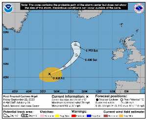
Friday, September 22 at 09:XNUMX UTC, when it dissipates, NIGEL was located at 46.3 N at -32.6 W (3147 km NE of Bermuda). Its intensity was 60 kts and its pressure of 976 hPa. This cyclone did not impact any territory.

NIGEL (Eg Invest 97L) is the 5th strongest cyclone recorded this season with a maximum wind of 85 kt or 157 kmh (the most powerful was LEE with a maximum wind of 145 kt i.e. 269 km / h). It was the 15th named cyclone of the 2024 season and is currently the 5th Category 2 hurricane of that same season.

NIGEL lasted 13 days.

NHC tracking for cyclone NIGEL​

Last statement of nhc before dissipation for cyclone NIGEL

Position

Dissipated

Category

Current Category: Dissipated
Max Category: Hurricane Cat. 2

Wind

Last reading: 60 kts / 111 km / h
Max: 85 kts / 157 km / h

Pressure

Last reading: 976 hPa
Mini: 971 hPa

NHC Bulletin


Forecast maps for

sources: nhc & NRL

nhc

Post-tropical cyclone Nigel: NHC forecast on Meteo Tropicale - Cyclone weather

NRL

Image not available

Translations are automated.

Current cyclones and Watching


Latest videos


ZCZC MIATCPAT5 ALL
TTAA00 KNHC DDHHMM

NEWSLETTER
Post-Tropical Cyclone Nigel Advisory Number 28
NWS National Hurricane Center Miami FL AL152023
900 AM GMT Fri Sep 22 2023

…NIGEL BECOMES EXTRATROPICAL…
…THIS IS THE LAST ADVISORY ON THIS SYSTEM…


SUMMARY OF 900 AM GMT… 0900 UTC… INFORMATION
----------------
RENTAL… 46.3N 32.6W
ABOUT 640 MI…1030 KM NNW OF THE AZORES
MAXIMUM SUSTAINED WINDS… 70 MPH… 110 KM / H
PRESENT MOVEMENT… NE OR 55 DEGREES AT 37 MPH… 59 KM / H
MINIMUM CENTRAL PRESSURE… 976 MB… 28.82 INCHES


WATCHES AND WARNINGS
-------
There are no coastal watches or warnings in effect.


DISCUSSION AND OUTLOOK
--------
At 900 AM GMT (0900 UTC), the center of Post-Tropical Cyclone Nigel
was located near latitude 46.3 North, longitude 32.6 West. Tea
post-tropical cyclone is moving toward the northeast near 37 mph (59
km/h), and this general motion is expected to continue for the next
day or so. A slower northward or north-northwestward motion is
expected this weekend.

Maximum sustained winds are near 70 mph (110 km / h) with higher
gusts. Gradual weakening is forecast during the next couple of
days

Tropical-storm-force winds extend outward up to 230 miles (370 km)
from the center.

The estimated minimum central pressure is 976 mb (28.82 inches).


HAZARDS AFFECTING LAND
--------
None.


NEXT ADVISORY
-----
This is the last public advisory issued by the National Hurricane
Center on this system.

$$
Forecaster Kelly

NNNN

ATTE

Disclaimer

TION

This site has been developed for entertainment and understanding the weather in the tropics.

It should only be used NEVER for the safety of people or property.

Only information from your national meteorological service and your civil security should be used in case of proven risk!

Account

Login

[user_registration_my_account]