Current cyclones and Watching


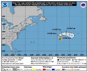
Sunday, September 17 at 15:XNUMX UTC, when it dissipates, MARGOT was located at 34.6 N at -42.4 W (2088 km E of Bermuda). Its intensity was 35 kts and its pressure of 1001 hPa. This cyclone did not impact any territory.

MARGOT (Eg Invest 96L) is the 6th strongest cyclone recorded this season with a maximum wind of 80 kt or 148 kmh (the most powerful was LEE with a maximum wind of 145 kt i.e. 269 km / h). It was the 14th named cyclone of the 2024 season and is currently the 7th Category 1 hurricane of that same season.

MARGOT lasted 13 days.

NHC tracking for cyclone MARGOT​

Last statement of nhc before dissipation for cyclone MARGOT

Position

Dissipated

Category

Current Category: Dissipated
Max Category: Hurricane Cat. 1

Wind

Last reading: 35 kts / 65 km / h
Max: 80 kts / 148 km / h

Pressure

Last reading: 1001 hPa
Mini: 970 hPa

NHC Bulletin


Forecast maps for

sources: nhc & NRL

nhc

Post-tropical cyclone Margot: NHC forecast on Meteo Tropicale - Cyclone weather

NRL

Image not available

Translations are automated.

Current cyclones and Watching


Latest videos


ZCZC MIATCPAT4 ALL
TTAA00 KNHC DDHHMM

NEWSLETTER
Post-Tropical Cyclone Margot Advisory Number 41
NWS National Hurricane Center Miami FL AL142023
300 PM GMT Sun Sep 17 2023

…MARGOT NO LONGER IN TROPICAL CYCLONE…
… THIS IS THE LAST NHC ADVISORY…


SUMMARY OF 300 PM GMT… 1500 UTC… INFORMATION
----------------
RENTAL… 34.6N 42.4W
ABOUT 885 MI… 1430 KM W OF THE AZORES
MAXIMUM SUSTAINED WINDS… 40 MPH… 65 KM / H
PRESENT MOVEMENT… WNW OR 300 DEGREES AT 9 MPH… 15 KM / H
MINIMUM CENTRAL PRESSURE… 1001 MB… 29.56 INCHES


WATCHES AND WARNINGS
-------
There are no coastal watches or warnings in effect.


DISCUSSION AND OUTLOOK
--------
At 300 PM GMT (1500 UTC), the center of Post-Tropical Cyclone Margot
was located near latitude 34.6 North, longitude 42.4 West. Tea
post-tropical cyclone is moving toward the west-northwest near 9 mph
(15 km/h). A clockwise turn resulting in a motion toward the east
is expected over the next couple of days.

Maximum sustained winds are near 40 mph (65 km / h) with higher gusts.
Small fluctuations in intensity are expected during the next few
days.

Tropical-storm-force winds extend outward up to 105 miles (165 km)
from the center.

The estimated minimum central pressure is 1001 mb (29.56 inches).


HAZARDS AFFECTING LAND
--------
SURF: Swells generated by Margot will continue to affect the Azores
for the next several days. These swells are likely to cause
life-threatening surf and rip current conditions. Please consult
products from your local weather office.


NEXT ADVISORY
-----
This is the last public advisory issued by the National Hurricane
Center on this system. Additional information on this system can be
found in High Seas Forecasts issued by the National Weather Service,
under AWIPS header NFDHSFAT1, WMO header FZNT01 KWBC, and online at
ocean.weather.gov/shtml/NFDHSFAT1.php

$$
Forecaster D. Zelinsky

NNNN

ATTE

Disclaimer

TION

This site has been developed for entertainment and understanding the weather in the tropics.

It should only be used NEVER for the safety of people or property.

Only information from your national meteorological service and your civil security should be used in case of proven risk!

Account

Login

[user_registration_my_account]