Current cyclones and Watching


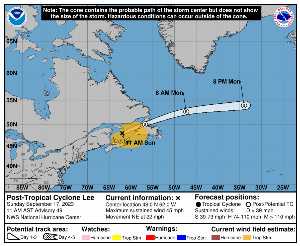
Sunday, September 17 at 15:XNUMX UTC, when it dissipates, READ was located on 48 N by -62 W (1763 km north of Bermuda). Its intensity was 40 kts and its pressure of 989 hPa. This cyclone did not impact any territory.

READ (Eg Invest 95L) is the most powerful recorded this season with a maximum wind of 145 kt or 269 kmh. It was the 13th named hurricane of the 2024 season and is currently the 1st Category 5 hurricane of the same season. LEE is now the 21st most intense cyclone in recorded history since 1950.

LEE lasted 16 days.

NHC tracking for cyclone LEE​

Last statement of nhc before dissipation for cyclone LEE

Position

Dissipated

Category

Current Category: Dissipated
Max Category: Hurricane Cat. 5

Wind

Last reading: 40 kts / 74 km / h
Max: 145 kts / 269 km / h

Pressure

Last reading: 989 hPa
Mini: 926 hPa

NHC Bulletin


Forecast maps for

sources: nhc & NRL

nhc

Post-tropical Cyclone Lee: NHC forecast on Meteo Tropicale - Cyclone Weather

NRL

Image not available

Translations are automated.

Current cyclones and Watching


Latest videos


ZCZC MIATCPAT3 ALL
TTAA00 KNHC DDHHMM

NEWSLETTER
Post-Tropical Cyclone Lee Advisory Number 49
NWS National Hurricane Center Miami FL AL132023
1100 AM AST Sun Sep 17 2023

…ALL TROPICAL STORM WARNINGS FOR CANADA ARE DISCONTINUED…
…THIS IS THE LAST ADVISORY ON LEE…


SUMMARY OF 1100 AM AST… 1500 UTC… INFORMATION
----------------
RENTAL… 48.0N 62.0W
ABOUT 135 MI…215 KM WNW OF PORT AUX BASQUES NEWFOUNDLAND
MAXIMUM SUSTAINED WINDS… 45 MPH… 75 KM / H
PRESENT MOVEMENT… NE OR 50 DEGREES AT 22 MPH… 35 KM / H
MINIMUM CENTRAL PRESSURE… 989 MB… 29.21 INCHES


WATCHES AND WARNINGS
-------
CHANGES WITH THIS ADVISORY:

Environment Canada has discontinued all Tropical Storm Warnings for
Canada.

SUMMARY OF WATCHES AND WARNINGS IN EFFECT:

There are no coastal watches or warnings in effect.


DISCUSSION AND OUTLOOK
--------
At 1100 AM AST (1500 UTC), the center of Post-Tropical Cyclone Lee
was located near latitude 48.0 North, longitude 62.0 West. Tea
post-tropical cyclone is moving toward the northeast near 22 mph (35
km/h), and a faster northeastward to east-northeastward motion is
expected over the next couple of days, taking Lee over Newfoundland
later today and over the Atlantic waters by early Monday.

Maximum sustained winds are near 45 mph (75 km / h) with higher gusts.
Continued gradual weakening is forecast during the next couple of
days, and Lee could dissipate on Tuesday.

Tropical-storm-force winds extend outward up to 290 miles (465 km)
from the center.

The estimated minimum central pressure is 989 mb (29.21 inches).


HAZARDS AFFECTING LAND
--------
Key messages for Lee can be found in the Tropical Cyclone Discussion
under AWIPS header MIATCDAT3 and WMO header WTNT43 KNHC and on the
web at hurricanes.gov/text/MIATCDAT3.shtml

WIND: Wind gusts to near gale force are still possible over
portions of Atlantic Canada today.

SURF: Swells generated by Lee continue to affect Puerto Rico,
Hispaniola, the Turks and Caicos Islands, the Bahamas, Bermuda, the
east coast of the United States, and Atlantic Canada. These swells
are likely to cause life-threatening surf and rip current
terms. Please consult products from your local weather office.


NEXT ADVISORY
-----
This is the last public advisory issued by the National Hurricane
Center on this system. Additional information on this system can be
found in High Seas Forecasts issued by the National Weather Service,
under AWIPS header NFDHSFAT1, WMO header FZNT01 KWBC, and online at
ocean.weather.gov/shtml/NFDHSFAT1.php

$$
Forecaster Pasch

NNNN

ATTE

Disclaimer

TION

This site has been developed for entertainment and understanding the weather in the tropics.

It should only be used NEVER for the safety of people or property.

Only information from your national meteorological service and your civil security should be used in case of proven risk!

Account

Login

[user_registration_my_account]