Current cyclones and Watching


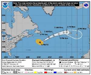
On Friday, September 1 at 21 p.m. UTC, when it dissipated, FRANKLIN was located on 39.5 N at -53.8 W (1272 km NE of Bermuda). Its intensity was 70 kts and its pressure of 979 hPa. This cyclone did not impact any territory.

FRANKLIN (Eg Invest 90L) is the 2th strongest cyclone recorded this season with a maximum wind of 130 kt or 241 kmh (the most powerful was LEE with a maximum wind of 145 kt i.e. 269 km / h). It was the 8th named cyclone of the 2024 season and is currently the 3rd Category 4 hurricane of that same season. FRANKLIN is now the 58th most intense cyclone in history since 1950.

FRANKLIN lasted 15 days.

NHC tracking for cyclone FRANKLIN​

Last statement of nhc before dissipation for cyclone FRANKLIN

Position

Dissipated

Category

Current Category: Dissipated
Max Category: Hurricane Cat. 4

Wind

Last reading: 70 kts / 130 km / h
Max: 130 kts / 241 km / h

Pressure

Last reading: 979 hPa
Mini: 926 hPa

NHC Bulletin


Forecast maps for

sources: nhc & NRL

nhc

Post-tropical cyclone Franklin: NHC forecast on Meteo Tropicale - Cyclone weather

NRL

Image not available

Translations are automated.

Current cyclones and Watching


Latest videos


ZCZC MIATCPAT3 ALL
TTAA00 KNHC DDHHMM

NEWSLETTER
Post-Tropical Cyclone Franklin Advisory Number 49
NWS National Hurricane Center Miami FL AL082023
500 PM AST Fri Sep 01 2023

…FRANKLIN HAS BECOME A POWERFUL EXTRATROPICAL CYCLONE…
… THIS IS THE FINAL NHC ADVISORY…


SUMMARY OF 500 PM AST… 2100 UTC… INFORMATION
----------------
RENTAL… 39.5N 53.8W
ABOUT 790 MI… 1270 KM NE OF BERMUDA
MAXIMUM SUSTAINED WINDS… 80 MPH… 130 KM / H
PRESENT MOVEMENT… NE OR 55 DEGREES AT 17 MPH… 28 KM / H
MINIMUM CENTRAL PRESSURE… 979 MB… 28.91 INCHES


WATCHES AND WARNINGS
-------
There are no coastal watches or warnings in effect.


DISCUSSION AND OUTLOOK
--------
At 500 PM AST (2100 UTC), the center of Post-Tropical Cyclone
Franklin was located near latitude 39.5 North, longitude 53.8 West.
The post-tropical cyclone is moving toward the northeast near 17 mph
(28 km/h). A faster northeastward motion is expected during the
next couple of days, followed by a turn to the east-northeast.

Maximum sustained winds are near 80 mph (130 km / h) with higher
tastes. Little change in strength is expected through tonight, but
gradual weakening is forecast this weekend into early next week.

Hurricane-force winds extend outward up to 60 miles (95 km) from the
center and tropical-storm-force winds extend outward up to 255 miles
(405 km).

The estimated minimum central pressure is 979 mb (28.91 inches).


HAZARDS AFFECTING LAND
--------
none


NEXT ADVISORY
-----
This is the last public advisory issued by the National Hurricane
Center on Franklin. Additional information on this system can be
found in High Seas Forecasts issued by the National Weather Service,
under AWIPS header NFDHSFAT1, WMO header FZNT01 KWBC, and online at
ocean.weather.gov/shtml/NFDHSFAT1.php

$$
Forecaster Reinhart

NNNN

ATTE

Disclaimer

TION

This site has been developed for entertainment and understanding the weather in the tropics.

It should only be used NEVER for the safety of people or property.

Only information from your national meteorological service and your civil security should be used in case of proven risk!

Account

Login

[user_registration_my_account]