Current cyclones and Watching


2 cyclones in the Atlantic basin in mid November and a third one coming!

Le 10 novembre 2020 à 18:46

By Olivier Tisserant
4.95/5 (92)

Reminder: the information and illustrations on this site are NOT INTENDED to protect property and people from cyclonic risks. For this, you must follow the information and recommendations of your prefecture for France and the competent authorities for other territories.

I haven't published for several weeks, so here's a little point as we approach the end of the season. This hurricane season 2020 in the Atlantic is totally out of the ordinary and is gradually breaking almost all existing records. There may be 3 simultaneous cyclones in mid-November, while this is already a fairly rare situation at the height of the seasonal peak.
 
In this outburst, the West Indies was almost totally spared (this is the main reason for my silence). We're not going to complain about it, but it gives a biased view of reality for people living in the area. I often hear people say “but no, it's not true, the season was very calm, I was not affected!”(So it must be a conspiracy 😉). But the season concerns the Atlantic basin as a whole, namely the ocean between the equator and 40N, the Caribbean Sea and the Gulf of Mexico. And in this area, there are 28 cyclones (the average being 12!) Including 12 hurricanes (6.5 on average) and 5 major hurricanes (2.7 on average). There are areas like the southern US that have been particularly affected with several major hurricanes (Louisiana).
 
And while we are in the 24th week of the season, there are 2 storms (Eta and Theta) and a Invest who threatens to be appointed quickly.

Storm Eta

The crazy ETA cyclone
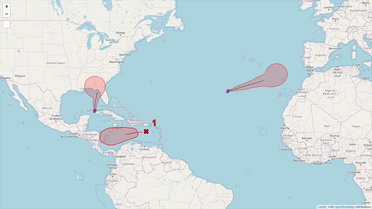
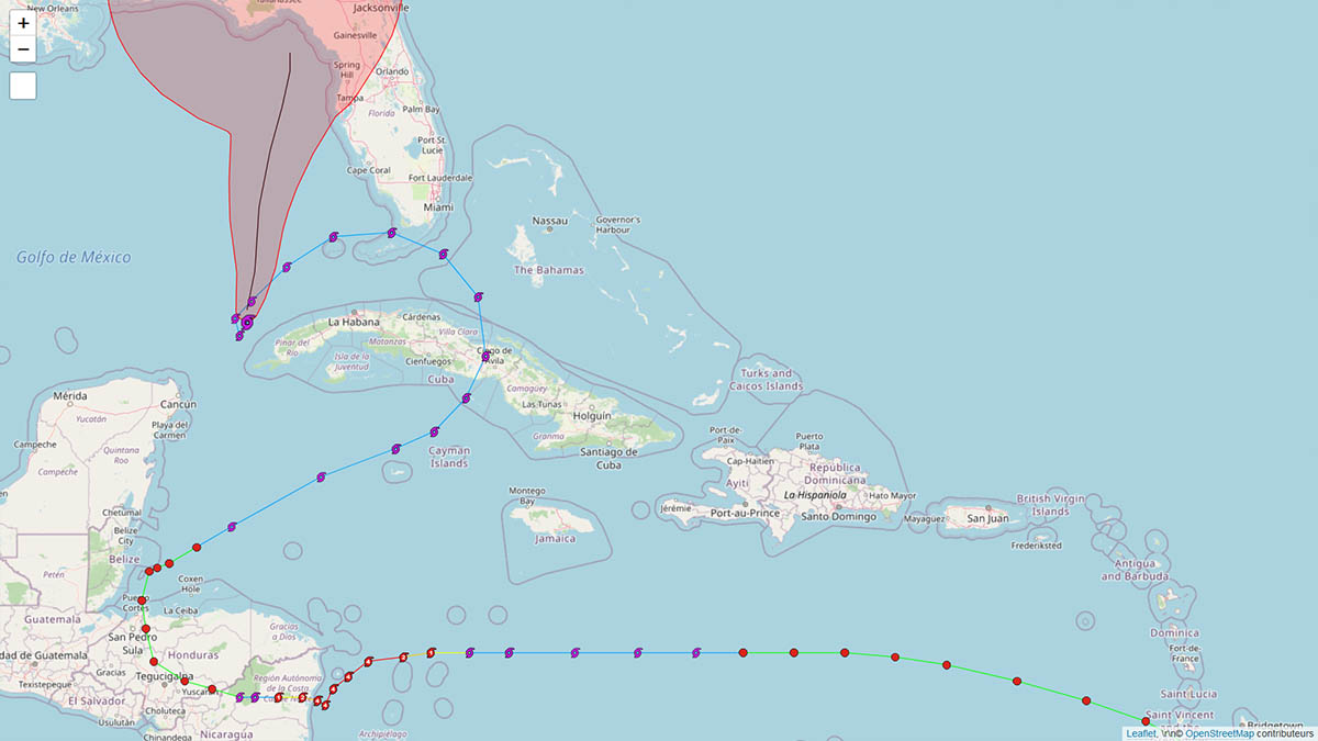
It will go down in history alongside those crazy cyclones with improbable trajectories and impressive reinforcements. After having had a huge impact on Nicaragua in category 4 and with a very slow movement speed on the coast, it crossed part of Central America before returning to the Caribbean Sea, crossing Cuba, then the Florida Keys before descending on Cuba and now turn around and go back up to threaten northern Florida. Storm Eta Probably represents what awaits us in the future with climate change, very complex systems with unusual variations in trajectory and intensity.

Storm Theta

Storm Theta in the Atlantic
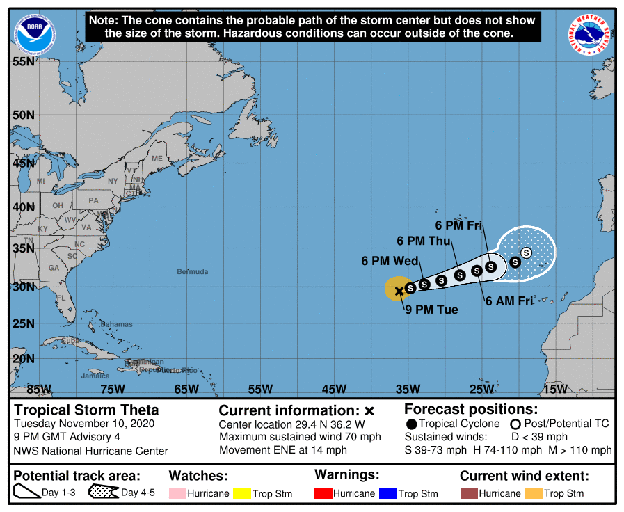
Let us note in passing that we are at a level of the Greek alphabet never before reached in history in the naming of cyclones, one of the sad records of the season!

Storm Theta also represents the abnormality of this season. An East trajectory at this latitude is really unusual. It shouldn't pose any big problems outside the Vendée Globe fleet, which will have to deal with its presence on the road. The nhc thinks she is at her peak intensity (60 kts) and that it will stabilize and weaken over the next few days.

Invest 98L

Here we are in the great classic of this season with a disturbance which is reinforced very quickly after having crossed the West Indies at the stage of tropical wave (if only 2 of all these waves had strengthened a few days before , the season would have seemed very difficult to us…. like what it does not depend on great things). The GFS sees it still touching Nicaragua at the stage of a hurricane and almost stationary. If that were to be the case it would be an indescribable disaster a few days after Eta's passage.

Conclusion

The people of the West Indian region should feel lucky and relieved to have (for the moment) gone through this extraordinary season without being worried. Because with nearly 30 cyclones, the probability of none having a strong impact on the region is about as low as winning the Loto (that's my Marseille side for the exaggeration!). Many people around the Caribbean Sea or the Gulf of Mexico would have liked to have had our chance. We will not shy away from our relief, but we must be aware that we have escaped the worst.

To be informed live of new articles, you can subscribe to the Facebook group or to the account Twitter.


Image credits; Tropical tidbits, NHC / Noaa, UW-CIMSS

Please rate this item

Comments

Subscribe
Notification for
guest
0 Comments
Online comments
Show all comments

Translations are automated.

Current cyclones and Watching


Latest videos

ATTE

Disclaimer

TION

This site has been developed for entertainment and understanding the weather in the tropics.

It should only be used NEVER for the safety of people or property.

Only information from your national meteorological service and your civil security should be used in case of proven risk!

Account

Login

[user_registration_my_account]