
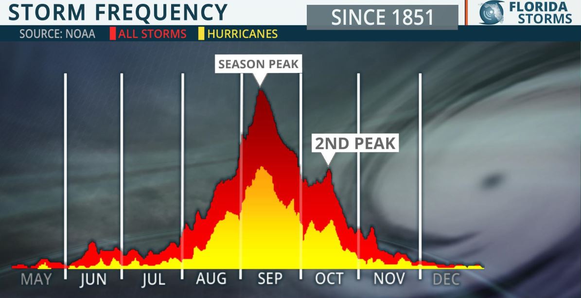
 As you can see from this graph we are really entering the statistically most active part of the hurricane season. During the next 7 to 9 weeks, we should record twice as many named systems and 2 times more cumulative ACE energy than in the previous 2,5 weeks, if we stick to the statistics since 11. Ca does not of course mean that this is what will happen or that such and such a territory will necessarily be impacted. It just means that, whatever we think, the hardest part is still ahead of us and we must prepare for it with great care.
And all the more so since the previous 11 weeks will have been the most active in the Atlantic basin since 1851. No less than 11 cyclones have been named, including 2 hurricanes. By way of comparison, the most active season to date, that of 2005, had recorded 8 cyclones on August 15. We are therefore on an extraordinary basis, literally. And this data can also be transposed into the accumulated ACE energy which is also the most important on August 15.
It is likely, if you live in the West Indian region for example, that you have not yet had any feeling of risk. This abnormally active start to the season mainly concerned the northern half of the tropical Atlantic with 60% of the systems having emerged above 20N. But just because it didn't concern you doesn't mean it's not real. And I can guarantee you that the people of the coast of South Carolina (or North) tremble every week with a hurricane system that threatens or directly affects them.
Catastrophism has no place. An active season planned on the Atlantic does not in any way mean that YOUR territory will have an active season as well. The 2005 season, with 26 named cyclones, saw the West Indies only hit once by a small Cat.1 in the far south. But in the whole basin there is little doubt that this season will be one of the most active in history.
But there is also no need to be a care bear and think that “it only happens to others ”. A season like this, which is predicted to have well over 20 cyclones, requires a lot of caution, preparation and attention. It is not because we are prepared and cautious that the risk increases!
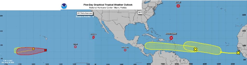
To give you a general idea of the situation, here is a collection of images from the nhc on the North Atlantic and the North-East Pacific!
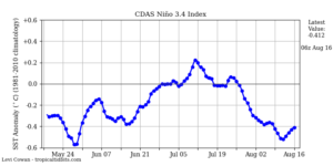 The water temperature in zone 3.4 is now mostly colder than average. We continue to have strong upward and downward spreads but it remains in the neutral cold phase overall. The forecast of a maintenance in the state for the fall is of the order of 50% even if some forecasters seem a little less affirmative.
Anyway, taking into account the low risk of abrupt descent and phase change La Nina very fast we can think that from now on an evolution would not impact the rest of the hurricane season (which is expected anyway with an activity usually recorded in phase La Nina quite intense).
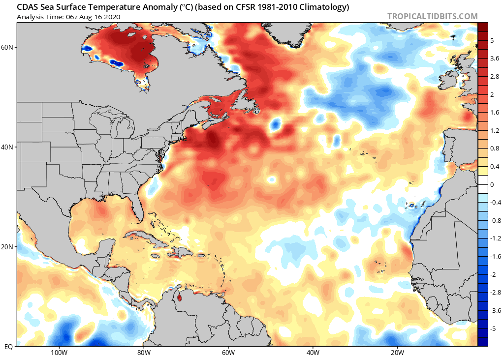 The pattern of water temperature anomalies in the tropical Atlantic is still largely impacted by sand haze, with areas remaining cooler than normal beneath the haze pockets. Overall, this situation greatly benefits the West Indian region since the water remains globally close to the average temperature in the major Atlantic development zone.
On the other hand, for the Caribbean, the Gulf of Mexico and the Bahamas zone, the anomalies are high and that does not bode well for the coming weeks, especially since these zones are little affected by the dry air and the sand in general. Only the shear as a bulwark against the next systems which will not fail to develop. Fortunately it is still rather present in these areas.
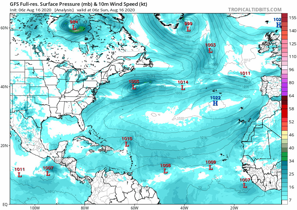
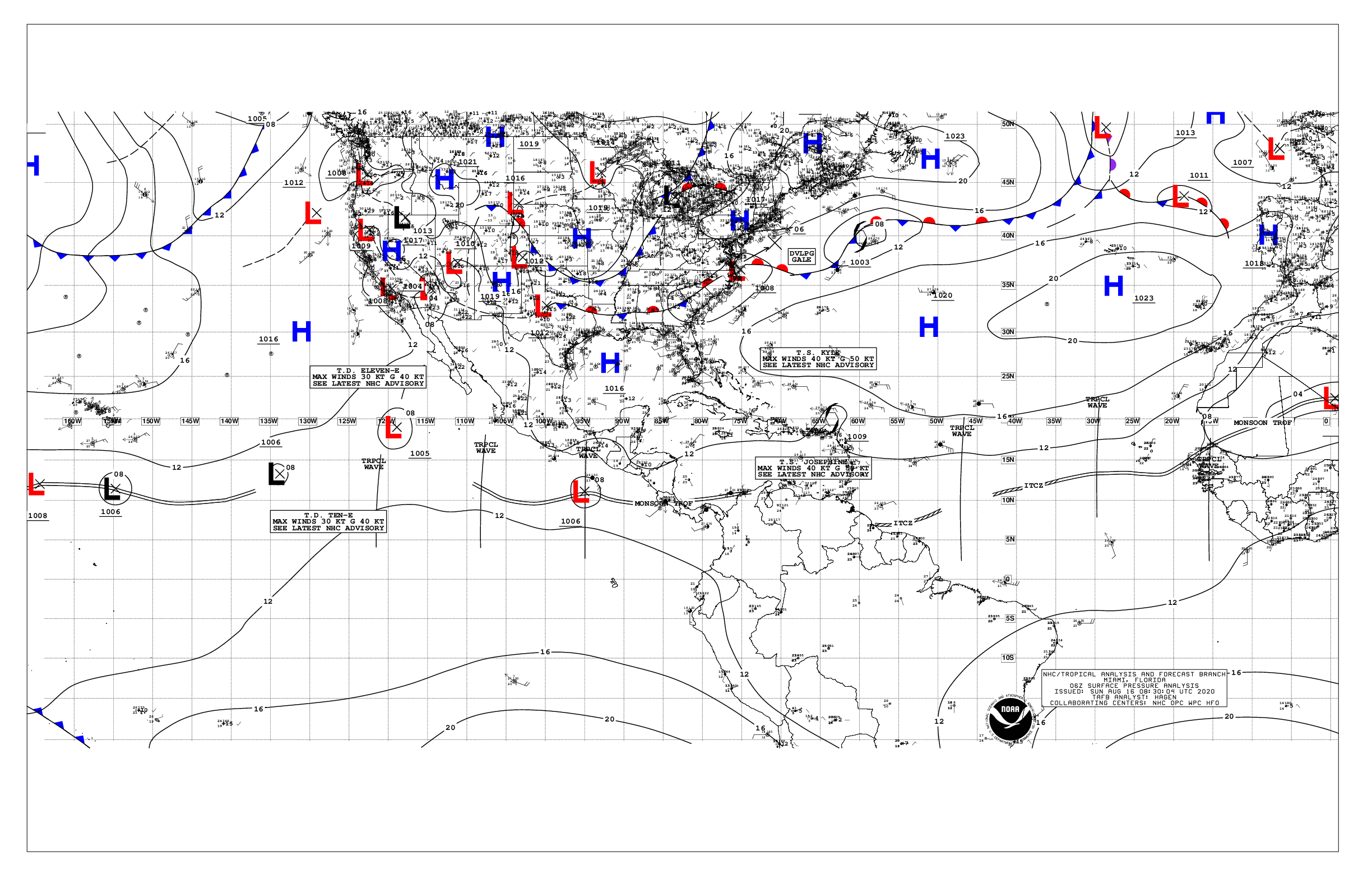 The Azores high is rather in its place with a ridge that joins the Bahamas but which should be pushed back a little to the east by the passage of what remains of Joséphine. However, the surface pressure situation in the Atlantic should remain fairly stable this week compared to the situation today, which should prevent the disturbances circulating on the Atlantic from rising to the north quite quickly.
3 waves circulate on the Atlantic. The 2 monitored by the nhc and one interspersed and completely surrounded by dry air.
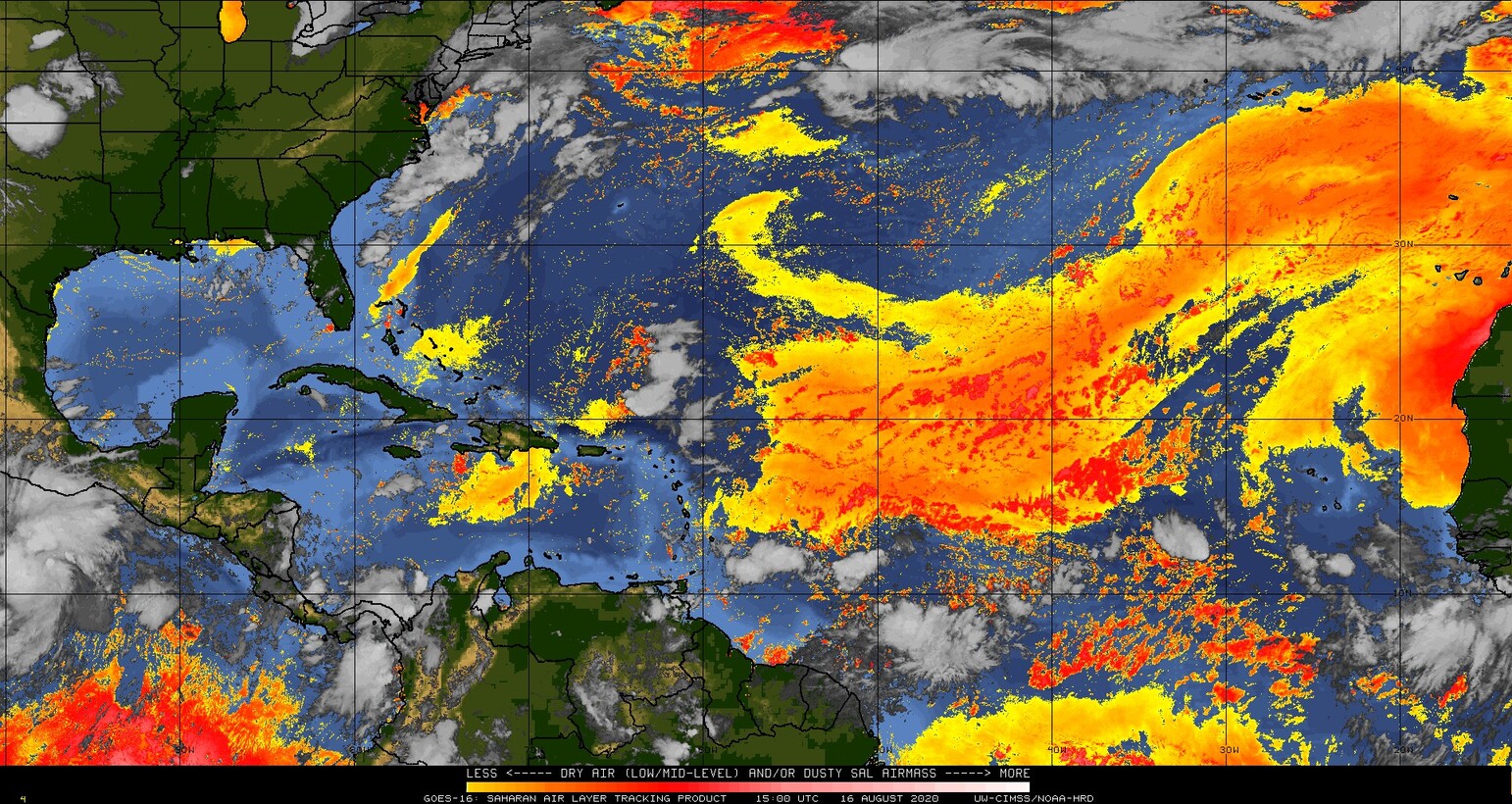 Although the areas of dry air and sand on the Atlantic are less dense and less regular; the fact remains that they are there and make it possible to somewhat limit the reinforcement of disturbances in the MDR and quite contain the increase in water temperature.
I know that for many these mists of sand are difficult but they still protect us a little from the appearance of a large cyclonic system on the West Indies. Even if it's not a panacea, it's better than nothing!
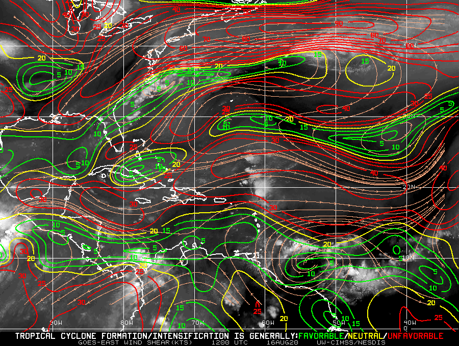 Le shear is extremely marked and contrasted in the major development zone. Very present above 15N, it unfortunately does not affect, or very little, the disturbances which circulate quite south and threaten the West Indies. This pattern is expected to be maintained over the next few days.
 Le nhc has not been idle for several weeks. And those who think (as I have read) that it amuses them to name systems “with a vengeance” should rather thank them for doing the same for territories that concern them very little (when they send Hunters in systems that are not intended to impact one of their territory directly, for example). In short, no, they are not having fun trying to scare us, and those who say this kind of nonsense would do better to inform themselves and educate themselves on the subject, that would prevent them from saying bullshit!
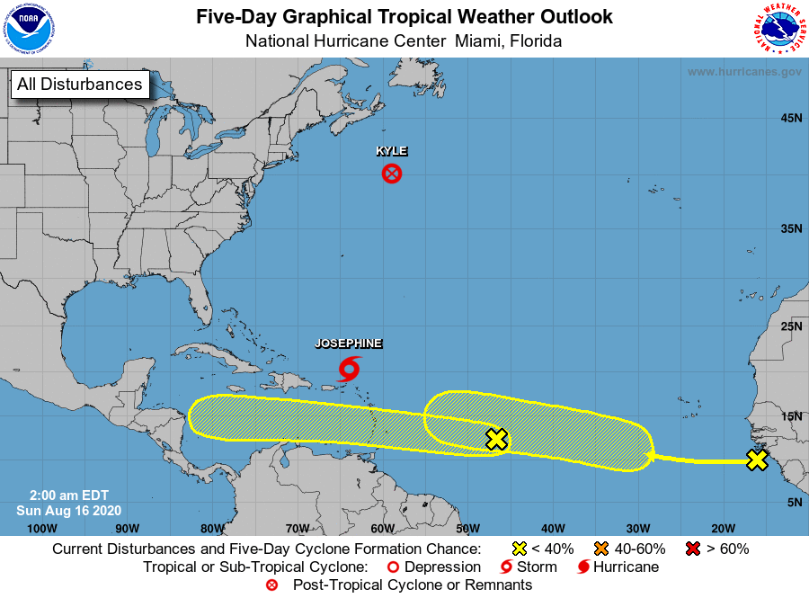
For the rest they follow Kyle who breaks up in the North Atlantic, Joséphine who weakens with the shear and 2 waves in the Atlantic which directly threaten the West Indies but are not classified in Invest for the time being.
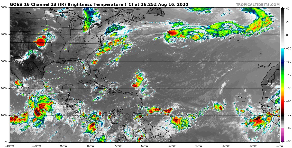 The IR satellite imagery perfectly shows the 2 waves monitored over the Atlantic, including the closest one which has a convection zone which should be of interest to the West Indies as of today.
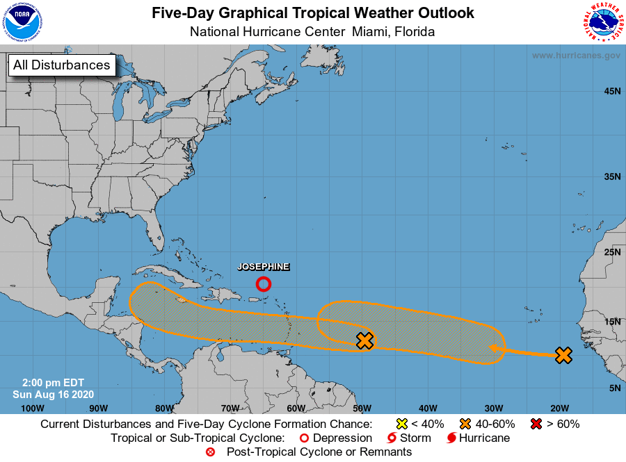 Le nhc has just raised its risk to 5 days for the 2 waves in the Atlantic.
For the one closest to the West Indies, that does not change much since it should have crossed the arc before being in more favorable conditions. It stays at 20 to 48 hours (which interests the West Indies) and drops to 40% in 5 days in an area without land for the first 4.
For the second, this change marks a better consideration of risk by the models. But we are still more than 5 days away and we will have to wait a bit (whether it is in Invest in particular) for more information. Nevertheless it is a good candidate for reinforcement before the arc.

