Current cyclones and Watching


Tropical storm Elsa was born in the Atlantic and threatens the West Indies

Le 1 juillet 2021 à 6:49

By Olivier Tisserant
4.96/5 (108)
This time, the south of the West Indies enters the heart of the matter. The wave that has agitated social networks and weather forecasting services for 3 days has greatly strengthened and the tropical storm Elsa was born overnight.
 
Here are the latest news and developments in recent hours.
Tropical Storm Elsa

It had been planned since last night and the nhc classified PTC5 as a tropical storm at the end of the night. This tropical storm named Elsa directly threatens the south of the Caribbean arc and should impact the area between Grenada and Martinique (perhaps a little further north depending on its size when crossing).

Intensity of storm Elsa

Elsa was classified as a storm at the minimum intensity of this stage, i.e. 35 kts. The forecast models are in consensus for a fairly rapid strengthening over the next 30 hours, that is to say by the West Indies, but they generally limit this strengthening within the framework of the storm stage. Only two models envisage a hurricane classification, one of which is traditionally very pessimistic.

Conditions remain favorable on its trajectory but the fairly marked acceleration of its movement (22 kts over the last hours) could limit its reinforcement potential by hampering its organization quite a bit.


Trajectory of Storm Elsa

For the trajectory, the consensus of the models is now very strong. Since yesterday, we have noted a southward shift in the forecast, which would now pass Elsa over Saint-Vincent and the Grenadines. Martinique is, suddenly and for the moment, out of the cone of trajectory uncertainty.
 
This situation is due, as I explained yesterday on the live (https://youtu.be/hpKIZdRFbBk) the presence of a high pressure ridge over Bermuda which constrains Elsa's track to the west.
 
However, this remains a trend and we must remain cautious on the exact trajectory which can still change a little by a few degrees and therefore potentially a hundred km in one direction or the other.

Risks for the territories

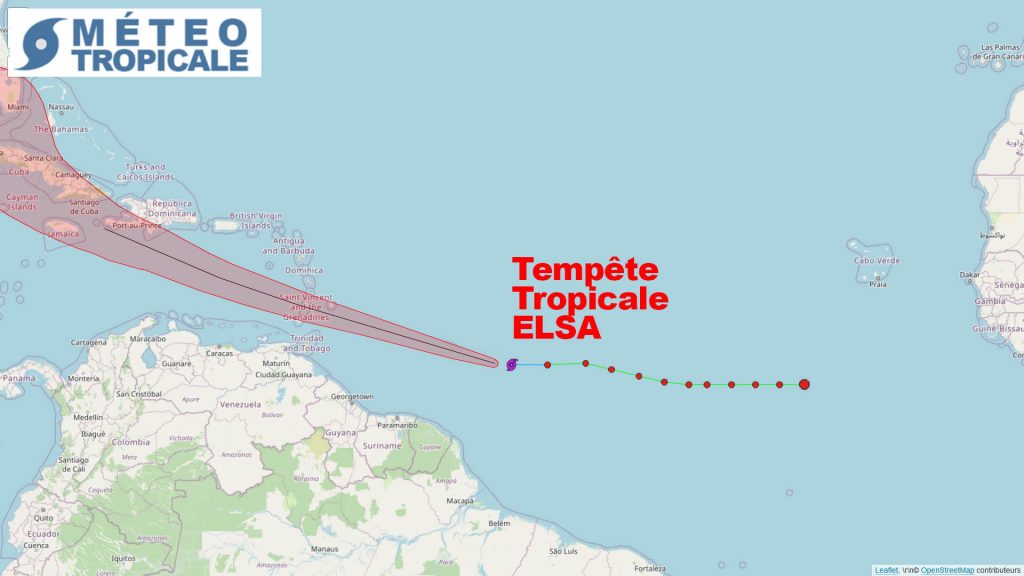
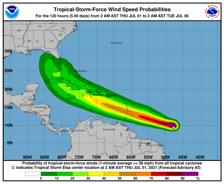
There are globally 3 areas with different risks:

- The zone of passage of the cyclone: ​​it is a standard cyclonic risk with strong wind from the north sector on approach, a little calm in the center and a big change in the south sector afterwards. rainfalls can be very heavy.

- To the north of the transit zone: there is a cyclonic risk linked mainly to the force of the wind and to rainfalls. No big changes in the direction of the wind but a very sustained wind throughout the duration of the phenomenon. The risk of heavy rainfalls is significant.

- To the south of the transit zone: the winds will be weaker but from the western sector dominant which can cause a very unusual disturbance on the Caribbean coast of the territories concerned (for the moment, south Saint-Vincent, Grenadines, Caricaou and Grenada ).

Conclusion

Tropical Storm Elsa is the 5th cyclone of the season. It thus breaks a record by being the 5th earliest cyclone of the season.

It represents a real risk for the south of the Caribbean arc. Boats in the Grenadines need to be very careful with the shifting wind to the west. For the territories located to the north of the trajectory, the wind could be very strong with gusts potentially of the order of 60 kts (Saint Lucia and Martinique). Even further north (Dominica and Saint-Vincent) the gusts can also sometimes be quite strong but without exceeding 45/50 kts. For the northern islands, there are no particular risks.

In tomorrow's point, I will talk about the risk for the Dominican Republic, Haiti and Cuba.


Image credit: Tropical tidbits, NOAA / NHC et UW-CIMSS

Please rate this item

Comments

Subscribe
Notification for
guest
0 Comments
Online comments
Show all comments

Translations are automated.

Current cyclones and Watching


Latest videos

ATTE

Disclaimer

TION

This site has been developed for entertainment and understanding the weather in the tropics.

It should only be used NEVER for the safety of people or property.

Only information from your national meteorological service and your civil security should be used in case of proven risk!

Account

Login

[user_registration_my_account]